Hells Hole Canyon
Hanksville Area\Dirty Devil River, Utah
ACA Rating: 3A II
1 rappel to 25’
Hanksville Area\Dirty Devil River, Utah
ACA Rating: 3A II
1 rappel to 25’
GENERAL DESCRIPTION:
A 2 to 4 hour hike with 1 rappel in an open canyon
which goes down to the Dirty Devil River.
GEAR:
Standard canyoneering gear.
Rope, webbing, and quick links for 1 rappel to 25 feet.
DRIVE:
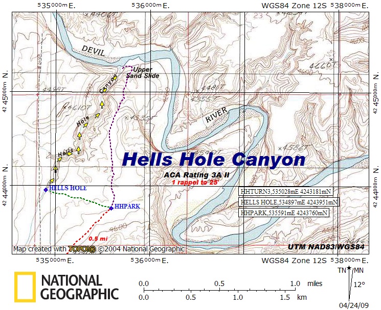
Drive south from Hanksville, Utah on Hwy 95 and turn left (east) at mile post 5.2. Drive 3.4 miles and turn left at HHTURN, UTM NAD83\WGS84 533170mE 4239534mN. Continue 1.5 miles and turn right at HHTURN2, UTM 533438mE 4241819mN. Drive 1.4 miles and turn left at HHTURN3, UTM 535028mE 4243181mN. Finally, drive 0.48 miles and park at HHPARK, UTM 535591mE 4243760mN. These dirt roads can be sandy and bumpy, but are generally passable to 2WD vehicles.
HIKE:
Hike across country to the west and make your way to the head of the canyon at HELLSHOLE, UTM 534897mE 4243951mN as shown on the map.
EXIT:
Upon completion of the canyon, return to your vehicle by way of the Upper Sand Slide as shown on the map.
COMMENTS:
Quality Rating: 
An open canyon with one small rappel at the beginning where you can leave your rope
to retrieve later. There is a nice sandy beach on the Dirty Devil River, just opposite of the mouth of the canyon.


